Arc en Cimes: The hundred highest road cols in the Arc Alpin
Introduction
This permanent randonnée from the Club des Cent Cols takes you to the 103 highest (paved) road cols in the Alpine Arc, 81 of which are over 2,000 metres and 22 of which are between 1,900 and 2,000 metres. These flagship coles are accompanied by two dozen lower cols – but often also meritorious – that mark the route between the giants. All the cols are paved, except two which are less than 90 metres from the road.
Minimum elevation: 115,500 m; Minimum distance: 5,000 km.
Traced by Mario Labelle (Cent Cols n ° 4889).
Route:
Theme
The Club des Cent Cols, founded in 1972 and affiliated to the French Federation of Cyclotouring, has prepared this “Randonnée Permanente” based on a simple theme: “One Hundred Cols”. The completion of these one hundred cols will allow you either to join the Club, or to progress with your list in the Club’s “Tableau d’Honneur”.
This route coversa hundred main cols of the Alps, located in four countries: France, Italy, Switzerland and Austria. It will certainly allow you to build up your list of 2000m cols.
This randonnée has a vertical climb in proportion to the cols it climbs: more than 115,500 vertical metres. What is perhaps less expected, however, is that the distance involved isn’t negligible as well. Indeed, the density of these highcols is rather low in comparison with certain hunting grounds like the Aude, the Drôme or Corsica. It is therefore only after more than 5,000 km that you will reach the finish line, an average of 48 km of pedalling per col.
Particulars
Out and back
To avoid extending an already very long route even further, we have decided – with regret – to offer some cols for out and backs, although served on both sides by a tarmac road. There are 16 cols like this, including Iseran, Lombard, Simplon, Bielerhöhe and several cols in Graubünden. Purists are free to do these cols on both sides if they wish!
Season preference
As in all Randonnées Permanentes of the Club des Cent Cols, “Arc en Cimes” can be done without time limit and in as many trips as the participant wishes. However, the roads of these high altitude cols are only open for a short season, which generally runs from mid-June to the end of September depending on the latitude, exposure to the sun and the severity of the previous winter.
Although this randonnée can easily be done in one trip during the cols ‘open season’, we recommend that you complete it over at least two years. The reason is related to summer traffic. Indeed, from mid-July to the end of August, most of these cols become real tourist attractions, very popular with motorcyclists. Not only are the roads congested, but they are extremely noisy and therefore not very user-friendly. If you want to complete it over a year, we advise you to do it in two separate trips: June 15 to July 15, then September 1 to 30.
Accommodation
The extent of the territory covered by this randonnée does not allow us to give an exhaustive list of accommodation. We therefore limit ourselves to providing the internet addresses of organizations offering accommodation or providing information on this subject, such as tourist offices, hotel groups, etc.
For each of the four countries participating in this randonnée, national and regional sites exist. In general, regional sites provide more detail than national sites. The list of regional sites is not exhaustive.
Please note that the information may be out of date, and that it is in your interest to check directly with the accommodation concerned the validity of the services, especially with regard to prices.
Please report to the officer any web links that do not work.
Controls
The randonnée, which is offered following the Alpine arc from southwest to northeast, begins in Nice and ends in Salzburg. It is divided into 7 sections, each (except the first and the last) starting and ending at a col. For each section, this table provides two lists of 6 checkpoints; on each list, you must have your route maps stamped in one of these 6 checkpoints, at your choice. Two checks per section are therefore required, totalling the fourteen stops necessary to complete the 7 sections of the randonnée.
Here is the list of sections whose numbers are to be included on the route maps (note: two route maps are required to collect these 14 stamps).
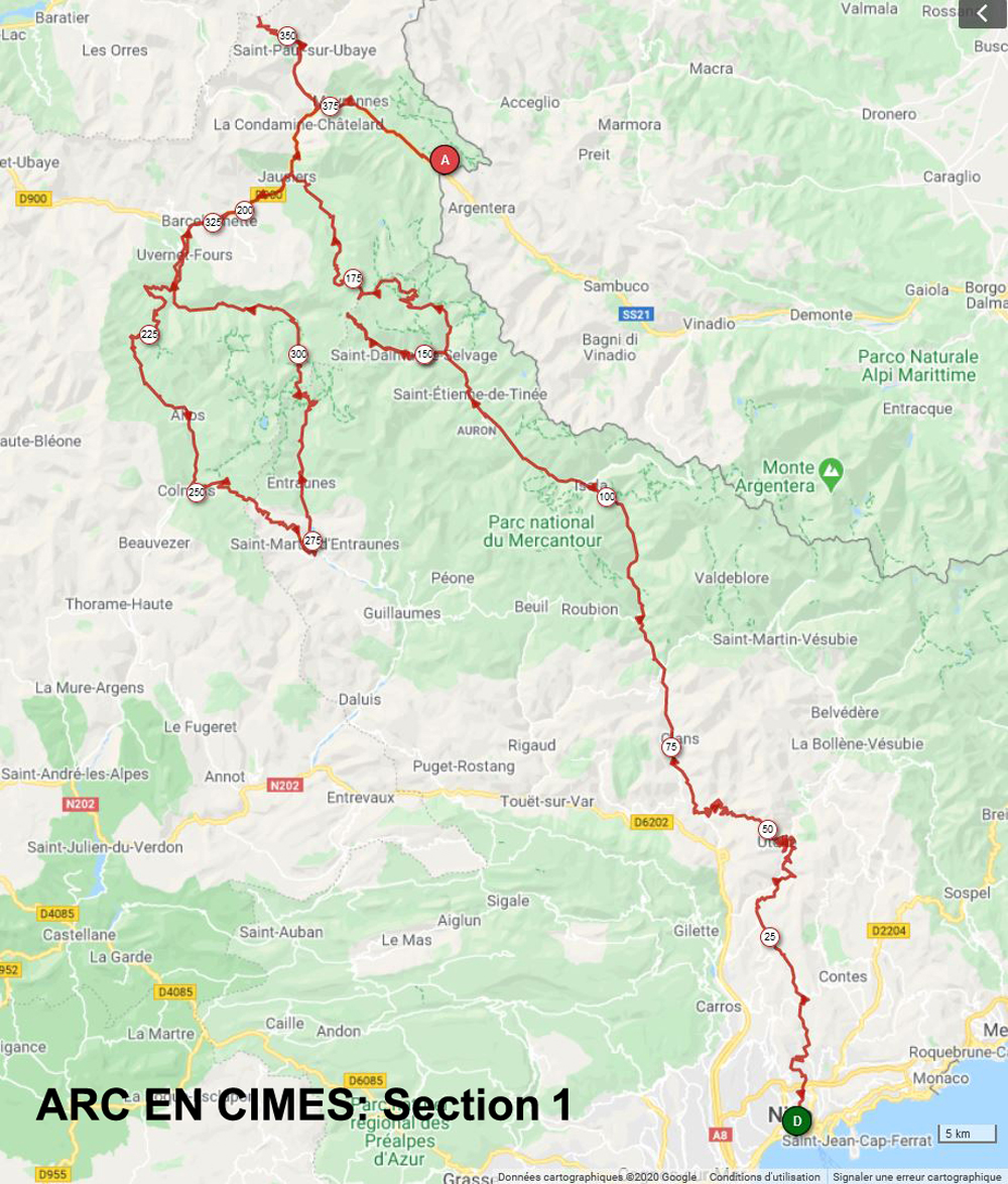
- Nice – Col de Larche (385 km, 9 passes, 10,365 m of climbing; climax: Col de la Bonette). After a symbolic dip in the water of the Baie des Anges, you begin the great adventure with this first section which covers the southernmost part of the Alps and which is exclusively in France in the departments of Alpes Maritimes and Alpes de Haute Provence . It is reached via the Tinée valley, and one discovers the cols radiating in the Ubaye valleys. Possibility of loops from Barcelonnette
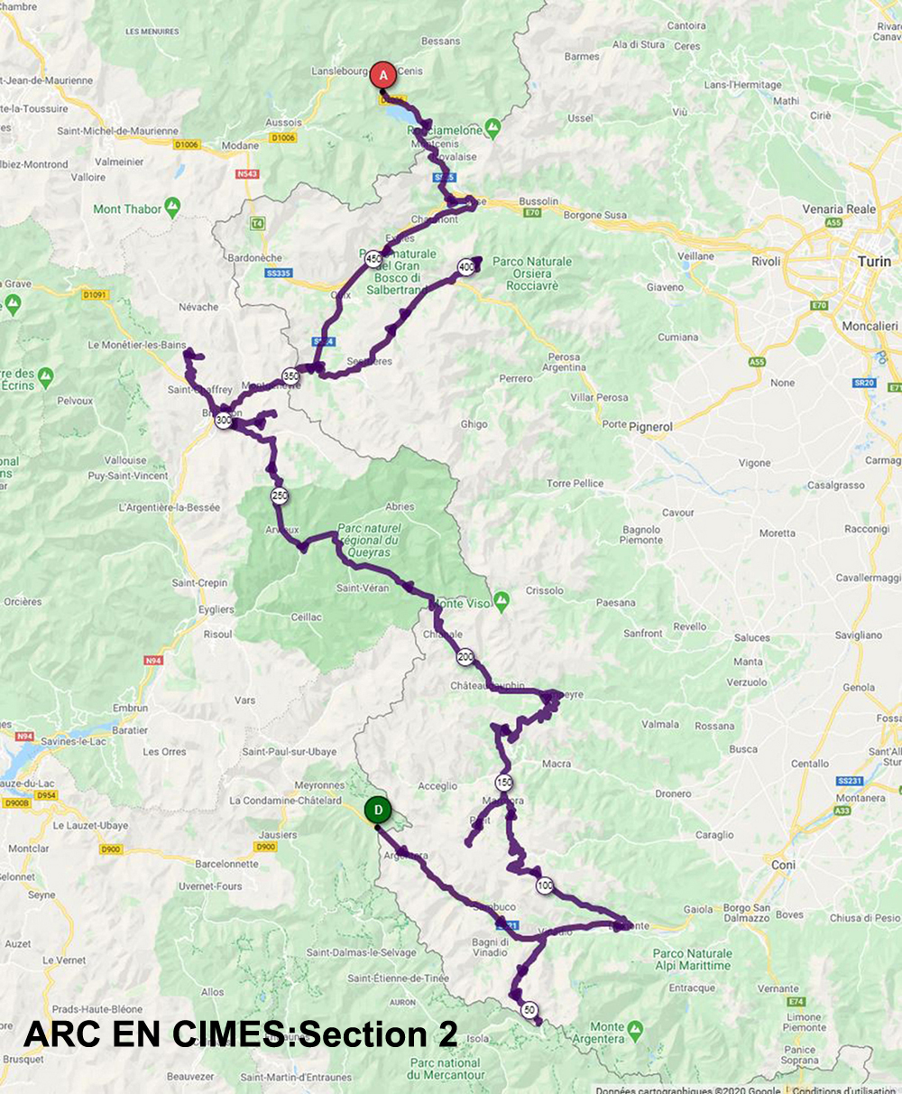
- Col de Larche – Col du Mt. Cenis (535 km, 17 cols, 25,710 m of climbing; highest point: Col Agnel). With this first foray into Italy, we soon discover one of the wildest and least touristic regions of our randonée. This region is entirely in the province of Cuneo and includes the valleys of Arma, Maira, and Varaita, and has one of the few high density col areas, with 4 cols in less than 4 km. The return to France is made by the Agnel pass; after Queyras we finally arrive at Briançon, useful base for the ascent of the neighboring cols. Second entry into Italy, this time for the picking of Sestriere, Olympic station of 2006, as well as Colle delle Finestre, tarred on its south face for the Giro in 2005. The brave will descend by the dirt road towards Susa, the fans of the tar will have to reach Susa by a return of 85 km which will inevitably pass by Sestriere. Return to France via the long Col de Mont-Cenis.
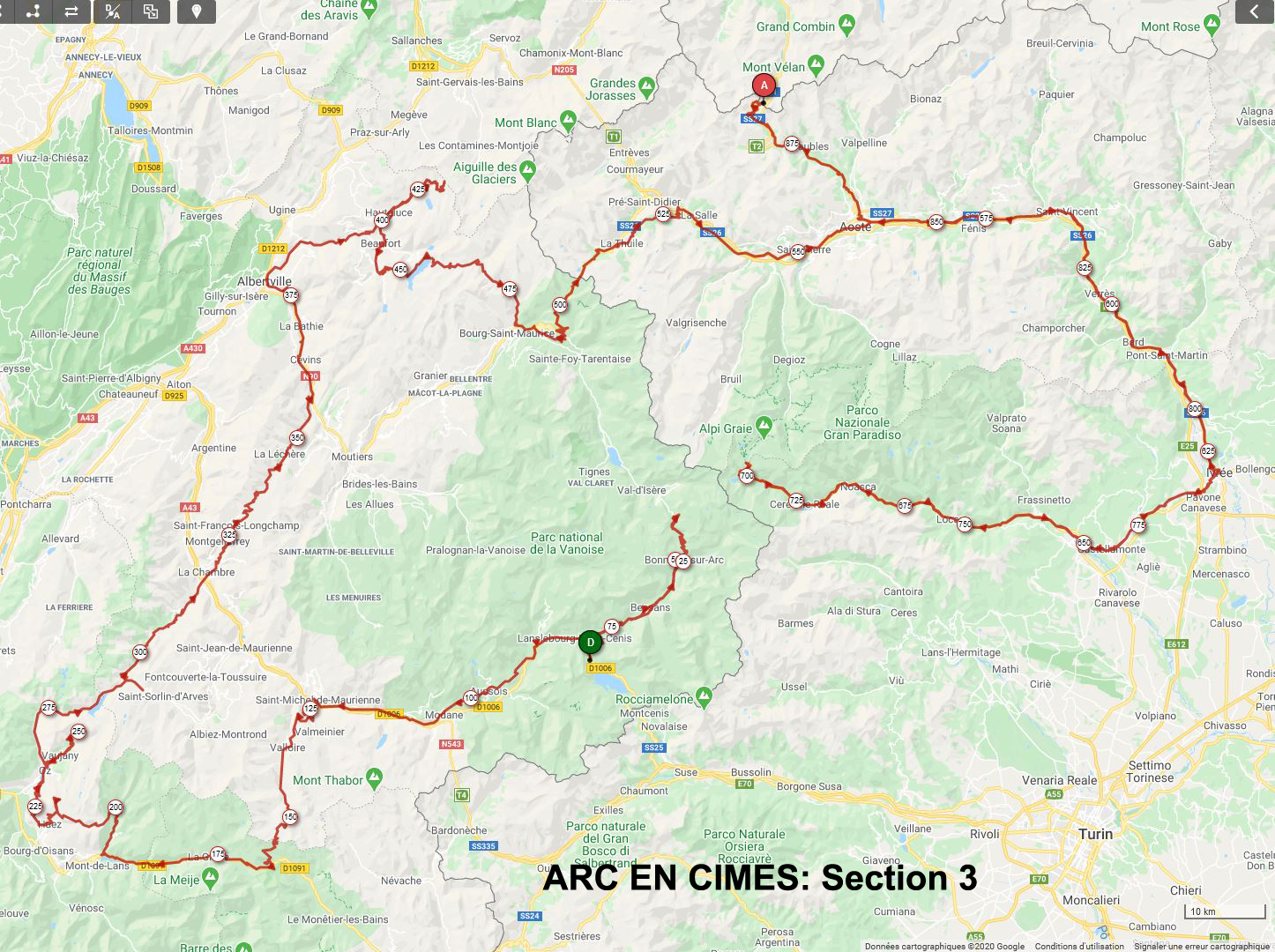
- Col du Mt. Cenis – Col du Grand St. Bernard (900 km, 16 cols, 20,730 m of climbing; highest point: Col de l’Iseran). We immediately get to the heart of the matter with the highest pass of the whole randonnée, the Col de l’Iseran, going there and back from the south. From valley to valley we follow the Arc, then the Romanche and the Olle, cross the Arc again, go up the Isère, touch the Haute-Savoie at the Col de Joly, and soon it’s farewell to France by the Petit St-Bernard. From Aosta, it will be 150 km before doing the Colle del Nivolet, one of the most spectacular of the trip. This col, located in the province of Turin 11 km from the Iseran Pass as the crow flies, is only accessible by road by a long detour that crosses the entire Valle d’Aosta, and goes up the Valle di Locana. With the 150 km return, this is by far the least “profitable” route of the trip! But soon we are in Switzerland…
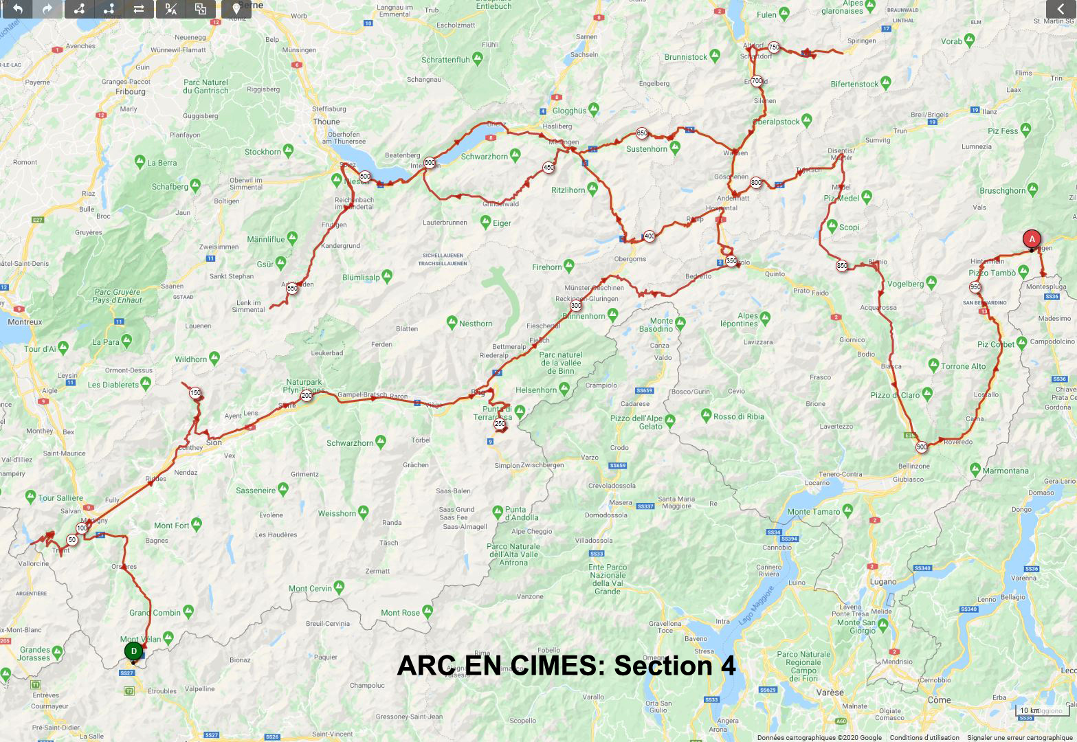
- Col du Grand St. Bernard – Splügenpass (1,030 km, 18 cols, 23,290 m of climbing; highest point: Furkapass). It is first of all the Valais, where the French language is left for the last time passing from “Valais” to “Wallis”, and then up to the foot of the large col loops of central Switzerland, bordering the cantons of Valais, Bern, Graubünden and Ticino. Switzerland’s water tower, these cols see the first runoff towards three seas, with the Rhône (Mediterranean), the Rhine (North Sea) and Ticino (Adriatic). A final little push west to glean a few scattered cols in the Bernese Oberland before pushing resolutely south-east. A trilingual canton, Graubünden welcome us in Romansh, then in Italian and finally in German, before the inevitable return to Italy by the Splügenpass.
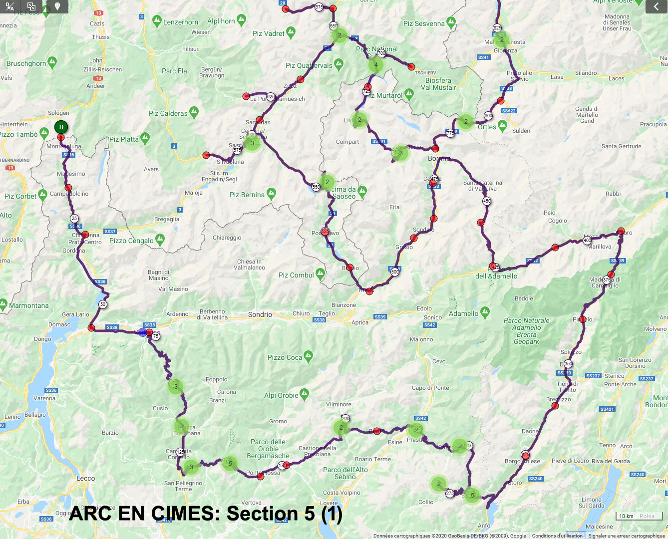
- Splügenpass – Timmelsjoch (1,115 km, 19 cols, 23,880 m of climbing; highest point: Passo dello Stelvio). The descent of the Passo dello Spluga is one of the most interesting from a civil engineering point of view, with its numerous tunnels, bridges, avalanches and works of art (including a hairpin in a tunnel). This section first introduces us to the southern cols of the Italian Alps in the provinces of Sondrio and Brescia, a region dotted with many famous lakes. Going north we now attack the legendary Gavia before descending on Tirano and finishing Switzerland with the ascent of all the Engadine cols. Back in Italy, we are now in the province of Bolzano, the “Süd tirol” of the Austrians, who offers us the jewel of his crown, the Stelvio. We are now ready to enter our fourth Alpine country, Austria. Two out and back cols, the Bielerhöhe, then the Kühtaisattel, gateway to the Ötztal. We finally go up this valley of the Ötztaler Ache to Timmelsjoch (Passo Rombo), where we find Italy
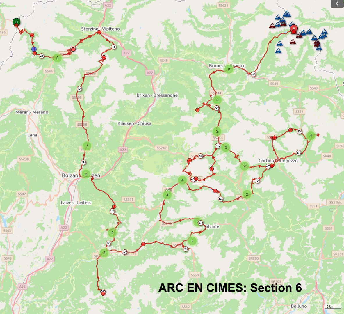
- Timmelsjoch – Passo di Stalle (615 km, 19 cols, 16,890 m of climnbing; highest point: ForcellaLongeres). This last section of Italy is devoted to the Dolomites and is located in the provinces of Bolzano, Trento and Belluno. Playground for mountaineers, paragliders as well as cyclists, the Dolomites will enchant you with their magical and magnificent landscapes. It is a feast for the eyes, and your average speed will suffer all the more since you will not be able to prevent yourself from stopping to take countless photos… And it is by these magnificent landscapes that we are leaving now, by a small alternative one-way road, this magnificent Italy, so fertile in cols. So we just have to finish Austria. Note two possibilities for loops.
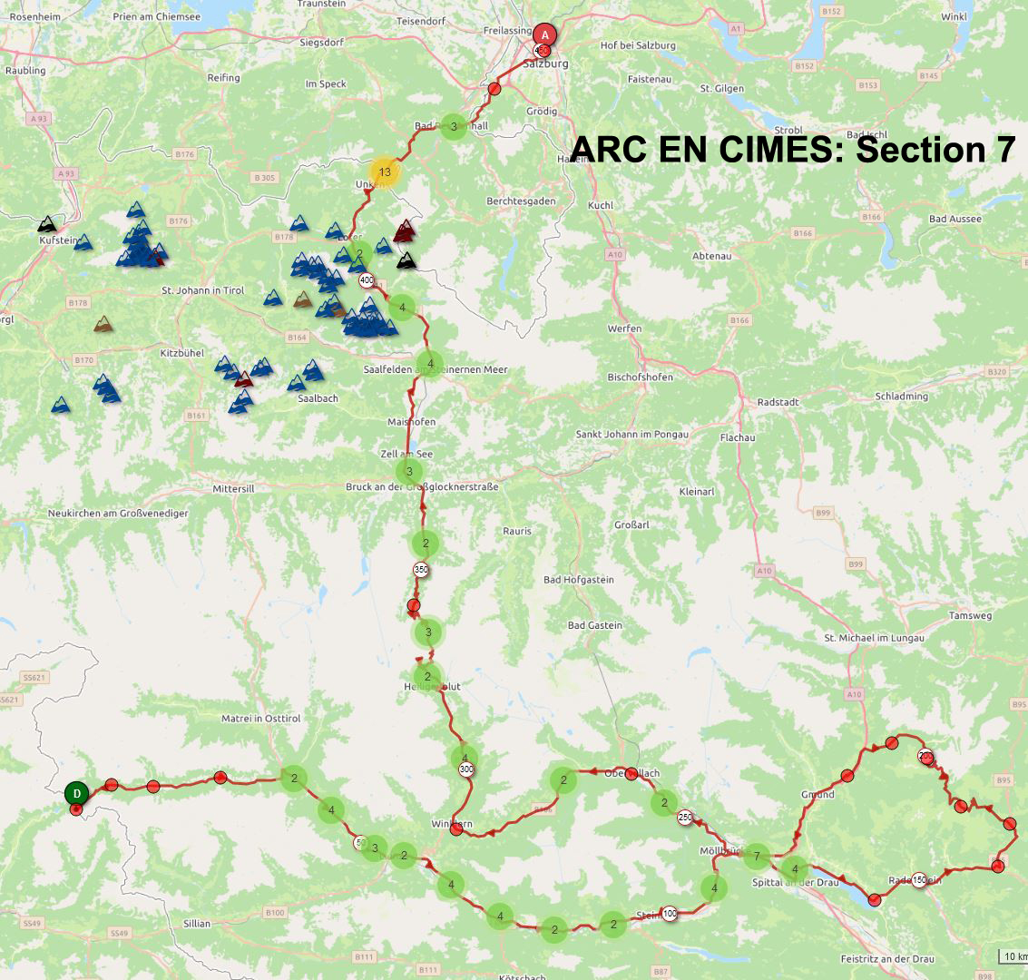
- Passo di Stalle – Salzburg (455 km, 5 cols, 4,815 m of climbing; highest point: Hochtor). From the Italian border, it will take 180 km east to find the next two cols, located on the tourist route to Nockalm, east of Carinthia. At the Schiestelscharte, the easternmost cols of the randonnée, we are further east than Berlin, almost at the longitude of Prague. These two Carinthian passes can easily be looped from Spittal or Möllbrücke. In Heiligenblut begins the long toll road with the equally long name, the Großglocknerhochalpenstraße. This magnificent road, in the heart of the Großglockner massif, crosses the state (Bundesland) of Carinthia to that of Salzburg, and will witness your passage from the last col of the trip, the FuscherTörl. More than 120 km and you will be at the birthplace of Mozart.
Principal cols
(You can locate all the cols of the randonnée on Google Earth)
- Col de l’Iseran
- Passo dello Stelvio
- Col Agnel
- Col de la Bonette
- Col du Galibier
- Passo di Gavia
- Hochtor (Großglockner)
- Col de la Lombarde
- Fuscher Törl
- Colle del Nivolet
- Colle dei Morti (Fauniera)
- Col du Grand St.Bernard
- Timmelsjoch / Passo Rombo
- Forcella Longeres
- Nufenenpass
- Furkapass
- Berninapass
- Fluelapass …
BCN and BPF sites on the route
The majority of the route being outside France, the only BPF / BCN sites are:
- Col de la Cayolle (04)
- Col d’Allos (04)
- St.Etienne-de-Tinée (06)
- Col d’Izoard (05)
- Col du Lautaret (05)
- Col du Glandon (73)
- Col de l’Iseran (73)
Rules of the randonnées permanentes
Any participant in this 100 Col Route agrees to respect the rules governing it.
More information
CONTACT:
Jean-Marc CLEMENT
10 rue de Normandie
31120 Portet sur Garonne
FRANCE
Tél : +33 (0)5 61 76 30 12
E-mail : randos@centcols.org