Challenge « Road Passes on the alpine watersheds »
Gérard Galland offers us this challenge:
to climb all the road cols located on the five main watersheds from the Alps
namely: 1 – North Sea / Adriatic, 2 – Western Mediterranean / Adriatic, 3 – North Sea / Western Mediterranean, 4 – North Sea / Black Sea , 5 – Black Sea / Adriatic.
80 cols and several countries included.
This challenge is open to members and non-members of the Club des Cent Cols.
Contact:
Registration form Format PDF Format Word
Goals
The objective of this challenge is also to encourage the participants to a detailed observation of the areas visited concerning the hydrographic network of the Alps and in particular to be interested in the future course of the waters flowing on both sides of the climbed cols .
The term “Ligne de partage des eaux” (LPE) – watershed in English – is mentioned in the comments on article 2 of our rules of the game, extract: “a place named on a cadastral map… .. with a title evoking a col, meets the RDJ , subject to…. , whether it is located on an LPE. ”
A watershed designates a geographical limit that divides a territory into two watersheds: on each side of the line, the waters flow towards two different rivers, or even two rivers, or even two seas or oceans.
The dividing line means separation. Often a border – political, linguistic … follows a watershed. Fortunately, communication is possible thanks to the crossing points… these crossing points have a name: “cols”.
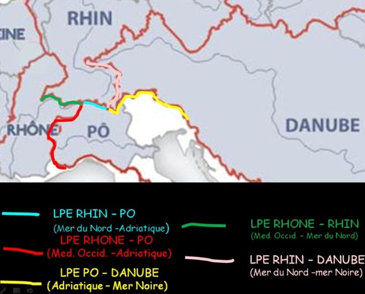
The Alps are considered to be the water tower of Europe; the main European rivers have their sources there. They feed 4 watersheds and 4 seas: the North Sea (with the Rhine and its tributaries), the Western Mediterranean (with The Rhône and its tributaries, the Var, La Roya, and the Ligurian coastal rivers), the Adriatic ( with the Po and its tributaries, the Adige, the Piave, the Tagliamento, the Soča) and the Black Sea (with tributaries of the Danube).
From 2 hydrographic tripoints (a hydrographic tripoint is a point where three watersheds meet) the Witenwasserenstock (Rhône – Rhin – Po) and the Lunghin Pass (Rhin – Po – Danube) both located in Switzerland, we can define 5 watersheds in the alps
- North Sea – Adriatic (almost entirely in Switzerland, short trip to Italy)

Splügen Pass (photo Gérard Galland) starting from Witenwasserenstock :
- West Mediterranean – Adriatic (in Switzerland, Italy and France)

col du Grand Saint-Bernard
- North Sea – West Mediterranean (entirely in Switzerland)

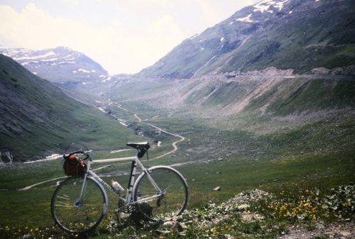
Col de Chaude (photo Gérard Galland)
Starting from Piz Lunghin :
- North Sea – Black Sea (in Switzerland, Italy, Austria and Germany)
Albula Pass (photo Daniel Cattin)
5. Black Sea – Adriatic (in Switzerland, Italy, Austria and Slovenia).
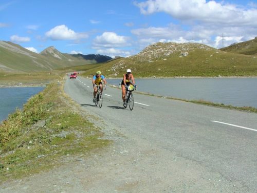
Val et Forcola di Livigno (photo Lucien Chevalier)
Descriptions of the watersheds and the cols located on them are available with the links above. A slideshow with maps and photos taken at the main cols is also available in connection with these articles.
Another approach is to focus on the “main” line of the Atlantic – Mediterranean watershed (LPE A / M) which, from the Czech Republic through the Sudetes massif and southern Germany, crosses the Alps ( LPE 4, 1 and 3 above) and extends west and south into the Jura then the Massif Central before crossing the Pyrenees, Spain and Morocco. This approach amounts to considering the Western Mediterranean, the Adriatic and the Black Sea as one sea. It makes LPE Mediterranean West – Adriatic (LPE 2), a LPE of “second order” … despite its passage through the Matterhorn, Mont Blanc, Mont Thabor and Mont Saccarel.
Significant documentation on this “main” LPE is available on the website of the “Watershed Line” association, which was created in 2014 with the “purpose of developing all activities related to the watershed between the Atlantic Ocean and the Mediterranean Sea (known as the “A / M line”). A recently created “By bike too” page is dedicated to crossing the EPL by bike
Rather than the infinite increase in the number of cols, many of us prefer the achievement of a geographically or culturally determined goal.
The challenge of the “inter-sea” Water Sharing Lines of the Alps aims in this spirit to invite participants to visit the cols located on these LPEs.
We also thought it would be interesting to offer this Challenge to non-members of the Club des Cent Cols in order to allow them to start a “collection of cols” in the heart of the Alps. We bring them our expertise on thesecols and we provide them with sophisticated IT tools. By this means, we hope to promote the joys and pleasures of discovery and cycling.
How it works
The Club des Cent Cols has created the “Inter-sea” Alpine Watershed Lines (LPEA) Challenge, the objective of which is to cross all the road cols located on these LPEs:
| 1 -LPE North Sea – Adriatic | 4 cols |
| 2 – LPE West Mediterranean – Adriatic | 27 cols |
| 3 – LPE North Sea – West Mediterranean | 17 cols |
| 4 – LPE North Sea – Black Sea | 9 cols |
| 5 -LPE Black Sea – Adriatic | 23 cols |
| Total (LPE Alps) | 80 cols |
The cols are those in the Club’s catalogues of the countries concerned at the date of signing up to a challenge. They are listed at the end of this document and in the excel table described below. This is used to declare cols. It is sent to the participant when registering.
The cols can be climbed in any order (but in accordance with the Rules of the Game for the 100 Cols club).
Circuits making it possible to reach – in the shortest distance – the cols of the various LPEs are proposed in the descriptive articles (see links in the objectives section).
Cols climbed before the creation of the challenge are taken into account.
• the watershed “platinum” challenge is obtained when the participant has climbed all the cols located on the five watersheds, ie. the 79 cols concerned.
• the watershed “gold” challenge is obtained when the participant has climbed all the cols located on the Atlantic-Mediterranean watershed (watershed a / m), ie 28 cols (9 for the North Sea / Black Sea watershed, 4 for watershed North sea / Adriatic and 16 for watershed North Sea / western Mediterranean),
• the watershed “silver” challenge is obtained when the participant has climbed all the cols of three watersheds (it can be conflated with the gold challenge, if these 3 watersheds are those of the Atlantic / Mediterranean watershed.
• the watershed “bronze” challenge is obtained when the participant has climbed all the cols of two watersheds.
Inscription
Download the registration form (pdf), or in Word format or request it from the LPEdesAlpes@centcols.org challenge manager
- A number will be assigned in the order of registration.
- A number will be assigned upon receipt of the challenge completion declaration
Upon receipt of the registration form, the person in charge will communicate to the applicant the declarative table in which the cols of each watershed are listed.
This table consists of 7 sheets, one for each of the 5 watersheds, and two summary sheets. It allows the participant to manage their list of climbed cols and to view their progress.
For each LPE, the names, altitudes, codes and accesses of the cols, as well as a link to the col viewer, are indicated in the corresponding sheet. For the border cols, the indications of the different catalogues have been included.
The participant will indicate in the column “date” information of his choice (in digital format: for example the climbing date or a serial number) for each climbed col, Excel will calculate the number of climbed cols for the corresponding LPE. This information will be automatically reported in the summary sheet. When all the cols located on an LPE are climbed, this will be indicated in the summary sheet. It will also indicate the level (of bronze to platinum) of challenge obtained.
The declaration is made by transmitting the completed Excel file (and named 999-NOM Challenge LPE Alpes – 999 = Registration number for the challenge) to the person in charge of the Challenge LPEdesAlpes@centcols.org, the person responsible analyzes the results and establishes the Tableau d’Honneur.
Once a participant has completed the “Gold” and “Platinum” challenges, and on their request, the challenge organiser will prepare a diploma certifying the completion of the “Gold Challenge” or “Platinum Challenge” of the “Ligne de Partage des Eaux des Alpes” (LPEA)
Participants can print this diploma themselves, or have it sent to them by the organiser at a cost of 6 Euros (this sum includes the cost of the special paper, and printing and postage). Only the diploma Platinum Challenge can be delivered by hand at one of the meetings of the Club.
A “Roll of Honour” of the holders and participants in each challenge (showing their progress) will be established. This list will be made available by the challenge organiser, after which a decision will be made on publishing the list in the Club publications. (Participants may request that their names be withheld from the published lists)
Rules of the challenge
-
- This challenge is open to members and non-members of the Club des Cent Cols.
- To register for the Challenge, you must: complete the registration form accepting these rules
- The goal of the Challenge is to cross all the cols located on the “inter-sea” LPE of the Alps. The list of cols is established by the Club des Cent Cols according to strict criteria of topography and toponymy.
- The cols must be climbed in accordance with the rules of the Club des Cent Cols.
- Each col climbed is declared as such on the good faith of the participant
- There is no time limit imposed
- A certificate is granted when all the cols located on the LPE of the Alps are climbed.
List of Cols
1 -LPE North Sea / Adriatic 4 cols
| 1 | Passo del San Gottardo / Gotthardpass | CH-TI-2091 | |
| 2 | Passo del Lucomagno / Lukmanierpass | CH-GR-1915 | |
| 3 | Passo del San Bernardino / Bernhardinpass | CH-GR-2065a | |
| 4 | Splügenpass / Passo della Spluga | CH-GR-2115b | IT-SO-2115 |
2 – LPE Western Mediterranean / Adriatic 27 cols
| 1 | Nufenenpass / Passo della Novena | CH-TI-2478b | |
| 2 | Simplonpass / Col du Simplon | CH-VS-2005 | |
| 3 | Col du Grand St. Bernard / Colle del Gran San Bernardo | CH-VS-2469a | IT-AO-2473 |
| 4 | Col du Petit Saint-Bernard | FR-73-2188 | IT-AO-2188 |
| 5 | Col du Mont Cenis | FR-73-2081 | |
| 6 | Col du Petit Mont Cenis | FR-73-2183b | |
| 7 | Col de l’Echelle | FR-05-1762 | |
| 8 | Le Mauvais Pas | FR-05-1779 | |
| 9 | Col de Montgenèvre | FR-05-1850 | |
| 10 | Col Agnel / Colle dell’Agnello | FR-05-2744 | IT-CN-2748 |
| 11 | Col de Larche / Colle della Maddalena | FR-04-1991 | IT-CN-1996 |
| 12 | Col de la Lombarde / Colle della Lombarda | FR-06-2350a | IT-CN-2351 |
| 13 | Col de Tende Ouest /Colle di Tenda | FR-06-1871 | IT-CN-1871 |
| 14 | Colla San Bernardo (di Mendatica) | IT-IM-1263 | |
| 15 | Colla Rinella | IT-IM-1281 | |
| 16 | Colla del Fieno | IT-IM-1242 | |
| 17 | Colla dei Boschetti | IT-IM-1229 | |
| 18 | Colle di Nava | IT-IM-0941 | |
| 19 | Colla di San Bernardo | IT-IM-1052 | |
| 20 | Passo di Prale | IT-CN-1269b | |
| 21 | Colle Caprauna | IT-CN-1376 | |
| 22 | Colle di San Bernardo | IT-CN-0957 | |
| 23 | Colle Scravaion | IT-SV-0820 | |
| 24 | Giogo di Toirano | IT-SV-0807 | |
| 25 | Colle di Melogno | IT-SV-1028 | |
| 26 | Bocchetta di Altare | IT-SV-0440 | |
| 27 | Colle di Cadibona (tunnel) | IT-SV-0435 | |
3 – LPE North Sea / Western Mediterranean 17 cols
| 1 | Furkapass /Col de la Furka | CH-UR-2429c |
| 2 | Grimselpass / Col du Grimsel | CH-BE-2165b |
| 3 | Col du Sanetsch / Sanetschpass | CH-VS-2252 |
| 4 | Col du Pillon | CH-VD-1546a |
| 5 | Col des Mosses | CH-VD-1445 |
| 6 | Col de la Pierre du Mouellé | CH-VD-1661 |
| 7 | Col d’Ayerne | CH-VD-1465 |
| 8 | Col de Chaude | CH-VD-1621 |
| 9 | Col de Jaman | CH-VD-1512 |
| 10 | Le Creux | CH-FR-1490 |
| 11 | Col de Belle Chaux | CH-FR-1510a |
| 12 | Col de Villard | CH-FR-1459b |
| 13 | Col de Rathevel | CH-FR-1233 |
| 14 | Seuil d’Attalens | CH-VD-0753 |
| 15 | Le Basset | CH-VD-0683 |
| 16 | Col de Gourze | CH-VD-0799 |
| 17 | Col du Chalet-à-Gobet | CH-VD-0872 |
4 – LPE North Sea / Black Sea 9 cols
| 1 | Julierpass | CH-GR-2284 |
| 2 | Albulapass | CH-GR-2312 |
| 3 | Flüelapass | CH-GR-2383a |
| 4 | Bielerhöhe | AT-7-2037a |
| 5 | Zeinisjoch | AT-7-1842 |
| 6 | Arlbergpass | AT-7-1793 |
| 7 | Flexenpass | AT-8-1773 |
| 8 | Hochtannbergpass | AT-8-1676 |
| 9 | Riedbergpass | DE-BY-1420 |
5 -LPE Black Sea / Adriatic 23 cols
| 1 | Passo del Maloja /Malojapass | CH-GR-1790 | |
| 2 | Passo del Bernina / Berninapass | CH-GR-2307 | |
| 3 | Forcola di Livigno | IT-SO-2315 | CH-GR-2315c |
| 4 | Passo di Foscagno | IT-SO-2291 | |
| 5 | Passo di Fraele | IT-SO-1952 | |
| 6 | Ofenpass / Pass dal Fuorn | CH-GR-2149b | |
| 7 | Passo di Resia / Reschenpass | IT-BZ-1507 | |
| 8 | Passo del Rombo / Timmelsjoch | AT-7-2474 | IT-BZ-2491 |
| 9 | Passo del Brennero /Brennerpass | AT-7-1370 | IT-BZ-1375 |
| 10 | Passo di Vizze / Pfitscher Joch | AT-7-2246 | IT-BZ-2251 |
| 11 | Passo di Gola / Klammljoch | AT-7-2288 | IT-BZ-2288 |
| 12 | Passo Stalle / Staller Sattel | AT-7-2052 | IT-BZ-2052 |
| 13 | Sella di Dobbiaco / Toblacher Sattel | IT-BZ-1209 | |
| 14 | Passo Monte Croce Comelico /Kreuzbergpass | IT-BL-1637 | |
| 15 | Passo di Monte Croce Carnico / Plöckenpass | AT-2-1357b | IT-UD-1360 |
| 16 | Passo di Pramollo / Nassfeldpass | AT-2-1530 | IT-UD-1531 |
| 17 | Sella di Camporosso | IT-UD-0814 | |
| 18 | Sella Nevea | IT-UD-1178 | |
| 19 | Passo del Predil / Predel | IT-UD-1156 | SI-1156 |
| 20 | Forcella della Lavina / Klanska škrbina | IT-UD-2068 | SI-2055 |
| 21 | Preval Vršič / Passo di Moistrocca | SI-1611 | |
| 22 | Bohinjsko sedlo | SI-1277 | |
| 23 | Postojnska Vrata | SI-0610 | |