

The Brevet de Randonneur des Alpes (BRA)
The BRA was created in 1936 by Gustave Darchieux and is organised by the Cyclotouristes Grenoblois.
The 51° Brevet de Randonneur des Alpes will take place on 15 and 16 July.
(Saturday 15 and Sunday 16 for the BAC (Brevet Alpin de Cyclotourisme) and Sunday 16 for the traditional 1-day event).
This cyclomontagne route – the most beautiful of its kind – will allow you to admire …. far
– from the Col du Glandon: Mont-Blanc,
– from the Col de la Croix de Fer: the Aiguilles d’Arves,
– from the Col du Galibier: the Massif des Écrins and the Meije.
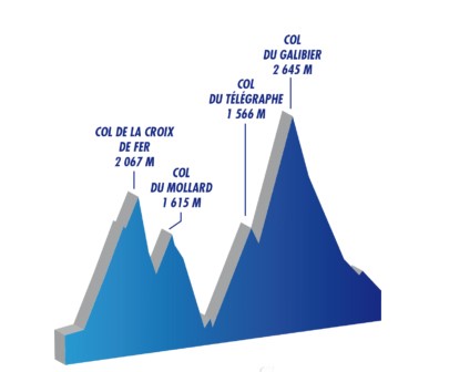
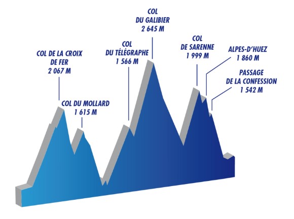
The BRA allows you to cross 8 passes (9 for the Super-BRA) including 4 passes over 2000 m ….
Departures (BRA and BAC) and accommodation (BAC)
Since the 50th edition (2019) the departure takes place from Bourg d’Oisans (which avoids, as was the case with previous editions, the tedious ascent (at night) of the Romanche valley from Vizille to Rochetaillé (and its descent on the way back !).
BAC: departure on Saturday from 7am to 10am
Accommodation in Saint Michel de Maurienne, Valmenier or Valloire (urgent online booking …)BAC
BRA : departures on Sundays at 4am, 5am and 6am.
The traditional route : BRA and BAC
174 km and 4,280 m of D+ – Option 1
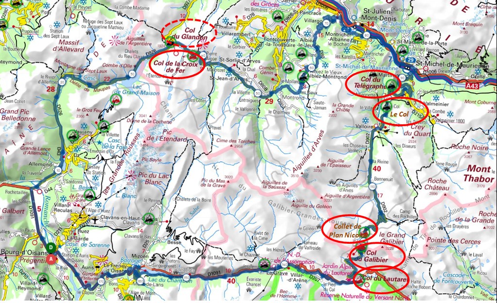
Departure from Bourg d’Oisans, voie verte left bank of the Romanche to Rochetaillé (lieudit Pont Rouge), then up the Vallée de l’eau d’Olle, via Allemond, the Barrage du Verney, the Rivier d’Allemond, crossing the Eau d’Olle, after a short descent, and a fairly steep ascent (11% for the first kilometre) – (the old road swept away in April 1989 by the Pic Brunard landslide is still visible on the right bank) – then to the right the Grandmaison dam and lake, at côte 1907 (2.7 km from the Col de la Croix de Fer, the crossroads to the Col du Glandon (FR-73-1924) at 250 m – pass hunters won’t want to miss the diversions and take the opportunity to admire Mont Blanc .
Checkpoint at Col de la Croix de Fer (FR-73-2064a) – facing the Aiguilles d’Arves.
Then down through Saint Sorlin d’Arves, up to the Col du Mollard (FR-73-1638), descent to the Maurienne via Albiez le Jeune and Villargondran (and the 48 lacets) ; up the Arc valley via Saint-Julien Mondenis to Saint Michel de Maurienne.
Ascent of Col du Télégraphe (FR-73-1566), on the short descent to Valloire, passing Le Col (FR-73-1522), then attack the main section : Les Verneys, Plan Lachat, to the right of the road Le Collet du Plan Nicolas (FR-73-2406) and … the Col du Galibier (FR-05-2642a), facing the Meige.
Descent to the Col du Lautaret (FR-05-2057), la Grave, the route will take in the voie verte (which was created as an emergency route after the collapse of the Chambon Tunnel), Chambon dam, le Freney d’Oisans and Bourg d’Oisans.
BRA+ and BAC+
182 km and 4,680 m of D+ – Option 2 in red on the map below
On the way back, at km 162, in Freney d’Oisans, the climb towards the Auris resort, up to Cerf d’Auris (1343 m), will allow you to return via the Belvédère de l’Armentier and admire the plunging view over the valley of the Romanche 600 m below !
Super BRA and Super-BAC
197 km and 5,200 m of D+ – Option 3 in green on the map
From the barrage du Chambon, head for Mizoën and Clavans via the Ferrand valley to reach the Col de Sarenne (FR-38-1999) (alas after much research we had to admit …. that we were a metre short of the 2,000 m mark)then on to Bourg d’Oisans via Alpe d’Huez.
Super BRA+ and Super BAC +
209 km and 5,252 m of D+ – Option 4 in green then purple
As you descend the Alpe, at Huez village turn right towards the Passage de la Confession (no ! it’s not a col !) and Villard-Reculas to return to Bourg d’Oisans via Allemond and its greenway on the left bank of the Romanche.
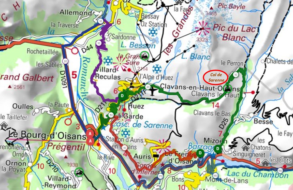
BRA+ and BAC+ in red, Super Bra and Super Bac in green, Super BRA+ and super BAC+ in green then purple.
Finally, for those wishing to take part in the festivities with a lighter route, a Discovery of the Oisans route (77 km and 1774 m of D+) is offered with the Col de Sarenne (FR-38-1999) or just the Balcon de l’Armentier (50 km and 1047 m of D+)